Live Traffic Predictions Guide for Woodlands and Tuas Checkpoints - Plan Smarter, Avoid Jams
Struggling with unpredictable traffic at Woodlands and Tuas checkpoints? Our Live Traffic Predictions feature on WoodlandsCheckpoint.com uses advanced AI to forecast traffic conditions, helping you avoid jams and save time. Designed for cross-border travelers between Singapore and Johor Bahru, this mobile-optimized tool is perfect for users on any device. Exclusive to paid subscribers, it offers precise predictions based on 14 years of data, updated every 15 minutes. Not a subscriber? Start your 7-day free trial today and experience hassle-free travel!
Why AI-Powered Traffic Predictions Are Essential
Mainly, it helps you avoid the frustration of getting stuck in heavy traffic at Woodlands or Tuas checkpoints. Unlike live cameras that only show current conditions, our Live Predictions tab forecasts future traffic real-time, enabling smarter planning. Whether you're a daily commuter or an occasional visitor to Johor Bahru, this tool helps you save time and reduce stress. Accessible without having to download any app or update it, it’s built to fit your on-the-go lifestyle.
Step-by-Step Guide to Using Live Traffic Predictions
Follow these steps to make the most of the Live Predictions tab and breeze through the checkpoints. Free users can unlock these features with a 7-day free trial.
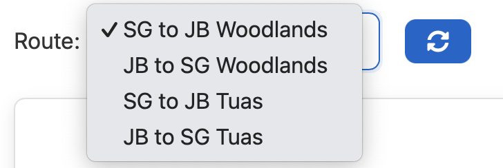
1. Select Your Route for Accurate Traffic Forecasts
- What It Is: A dropdown menu to choose your travel path, such as Singapore to JB via Woodlands or JB to Singapore via Tuas. You can select any of the 4 routes.
- How to Use It:
- Log in with your mobile number using a quick OTP via SMS - no complicated sign-up required. This is handled securely by Google.
- Access the Live Predictions tab on your phone, tablet, or desktop.
- Select your route from the dropdown.
- Why It’s Great: Access traffic forecasts for your specific journey, whether via Woodlands or Tuas, with just your mobile number.

2. Understand the Travel Time Chart for Checkpoints
- What It Shows: A 24-hour line chart predicting travel times for your route. The timings show the duration from start (e.g., road leading up to Woodlands checkpoint) to finish (e.g., JB road after CIQ). Applies to and fro, for both Woodlands and Tuas checkpoints.
- How to Read It:
- The horizontal axis displays time slots (e.g., 1 PM to 2 PM) in 30-min intervals.
- The vertical axis shows travel time in minutes.
- The view will be tailored to your device, be it mobile, desktop, or otherwise.
- Lower points indicate faster trips; higher points signal delays.
- Updated every 15 minutes
- How to Use It: Identify dips in the chart to find the best time to travel. For example, if the chart shows 25 minutes at 3pm but 50 minutes at 4.30pm, leave earlier to avoid congestion.
- Why It’s Great: The displayed chart trends (i.e. highs and lows) help you plan around peak traffic conditions at the checkpoints.
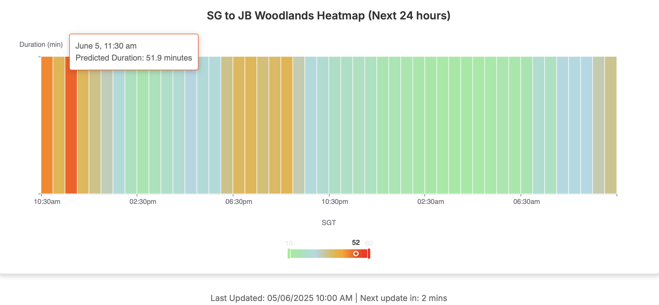
3. Navigate with the Congestion Heatmap
- What It Is: A color-coded map showing traffic intensity across time slots. It displays a full spectrum of colours depending on the exact nature of traffic at that moment with the predicted timings shown when you hover or click on it.
- How to Read It:
- Greenish: Smooth, fast travel.
- Yellowish: Moderate traffic, expect minor delays.
- Reddish: Heavy congestion, avoid if possible.
- How to Use It: Choose green or blue time slots for the easiest drive. Updated every 15 minutes, the heatmap ensures you have the latest traffic updates.
- Why It’s Great: The visual nature of the heatmap helps you quickly spot potential delays before they slow you down, especially during busy periods like school holidays or other major events.
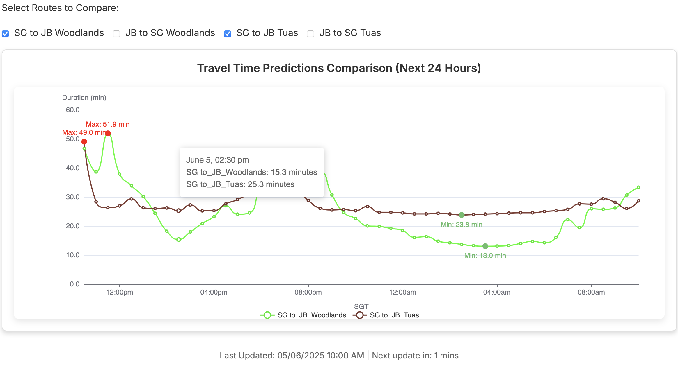
4. Compare Routes for the Fastest Path
- What It Does: Compares travel times between routes within or across Woodlands and Tuas checkpoints.
- How to Use It:
- Scroll to the “Select Routes to Compare” section.
- Check the boxes for routes you’re considering.
- Review the comparison chart to identify the quickest checkpoint.
- Why It’s Great: A common use-case is to compare 2 checkpoints and understand which one is better for that day's journey, if you are considering either. Secondly, you can also use the route comparison to understand the best times to go to JB and come back through the same checkpoint. It helps you make informed decisions to select the fastest route, avoiding heavy traffic jams.
Practical Applications for Cross-Border Travelers
The Live Predictions tab transforms your travel experience, whether you’re a frequent commuter or an occasional traveler. Here’s how:
- Plan Efficiently: Check predictions the night before to choose a low-traffic window for your JB or SG trip. Check the traffic again in the morning for the freshest set of data and latest updates.
- Choose the Best Checkpoint: Compare Woodlands Checkpoint and Tuas Checkpoint traffic predictions to find the fastest route.
- Make Smart Stops: Near the checkpoint? See if waiting 20-30 minutes could halve your travel time.
- Combine with Live Cameras and Weather Forecasts: Pair predictions with live traffic cameras and weather forecasts for a complete view of current and future conditions. Together, these give you true predictive power.
- Save Time: Frequent travelers can save over 50 hours a year by avoiding major causeway traffic gridlock.
Not a subscriber? Start your 7-day free trial to unlock these tools and travel stress-free!
Trust Traffic Trends, Even If Predictions Aren’t Perfect
Sometimes, the authorities on both Singapore and Malaysian side might close a lane, do a spot check, or something else that delays the traffic flow unexpectedly. During these periods, it is possible that the predicted timings aren't 100% accurate - there may be a slight error margin. While unforeseen events like these, or accidents and roadworks can affect precise timings, the traffic trends these predictions reveal are what truly matter. Built on 14 years of historical data, these trends show consistent patterns for peak hours with granular detail about each 30-min interval or lighter traffic gaps you can take advantage of, giving you a dependable foundation for planning.
Why is this so important? By tapping into these traffic trends, you can plan travel in advance and dodge heavy jams that even seasoned travellers can get stuck in. For instance, if the trend shows congestion spiking this evening, leaving an hour earlier could cut your wait time in half. This proactive approach saves you from the stress of gridlock and keeps your schedule on track. So, even if the exact minute-by-minute forecast shifts, the bigger picture - the reliable trends - ensures you’re making smart, time-saving decisions.
Tips to Maximize Your Live Predictions Experience
- Stay Updated: Refresh the pages for the latest traffic data, especially during peak periods so that you utilize the freshest dataset.
- Go Mobile: Our mobile-optimized site lets you check predictions on the go, perfect for travelers.
- Check Weather Conditions: Use the Live Traffic tab’s weather forecasts to see if rain might impact checkpoint traffic.
- Manage Your Subscription: Update contact or billing details easily via the “Manage Subscription” or "Update Contact" buttons.
Troubleshooting Common Issues
If predictions don’t match actual conditions, unforeseen events like accidents or road closures may be the cause. Check live cameras or news outlets for real-time updates and adjust your plans accordingly. For any issues, contact our support team via [email protected] or the contact form on our site.
Travel Smarter with Live Predictions
Take control of your cross-border journeys with Live Traffic Predictions. Whether you’re avoiding Woodlands Checkpoint traffic or navigating Tuas Checkpoint traffic, our tool provides the insights you need for smoother trips. Designed for any device, it’s perfect for commuters and casual travelers alike. Start your 7-day free trial today and join other savvy travelers saving time and stress!